Gibson Desert
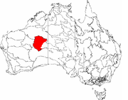
The Gibson Desert covers a large dry area in the state of Western Australia and is still largely in an almost "pristine" state. It is about 155,000 square kilometres (60,000 square miles) in size, making it the 5th largest desert in Australia, after the Great Sandy, Great Victoria, Tanami and Simpson deserts.
Contents |
Location and description
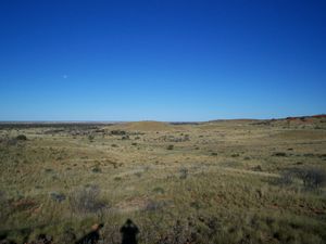
The Gibson Desert is located on the central Western Australian plateau between the saline Lake Disappointment and Lake Macdonald along the Tropic of Capricorn, south of the Great Sandy Desert, east of the Little Sandy Desert, and north of the Great Victoria Desert. The altitude rises to just above 500 meters in places. As noted by early Australian explorers such as Ernest Giles [1] large portions of the desert are characterized by gravel-covered terrains covered in thin desert grasses and it also contains extensive areas of undulating red sand plains and dunefields, low rocky/gravelly ridges and substantial upland portions with a high degree of laterite formation. The sandy soil of the lateritic buckshot plains is rich in iron. Several isolated salt-water lakes occur in the centre of the region and to the southwest a system of small lakes follow paleo-drainage features.[2] Groundwater sources include portions of the Officer Basin and Canning Basin.
Rainfall in the Gibson Desert ranges from 200 mm (7.8 in) to 250 mm (9.8 in) annually, while evaporation rates are in the 3600 mm/yr range. The climate is generally hot; summer maximum temperatures rise above 40°C (104°F) whilst in winter the maximum may fall to 18°C (64°F) and minimum winter temperatures dip to 6°C (45°F).[3]
History
The Gibson Desert was named after the explorer Alfred Gibson who died during an expedition here led by Ernest Giles in 1874.
Engendered exploration
It is believed that Vera Ivy Fowler was the first European woman to cross the Gibson Desert by land. In 1962 she and her husband travelled, as part of a Commonwealth Government seismic survey, exploring the area for potential for oil or gas reserves. The Gunbarrel Highway had been pushed through the area in 1958 as part of a plan to open up the country in connection with the Woomera rocket range activities. The party left Alice Springs on 6 September 1962, travelling by road to Kulgera and then to Mulga Park and the abandoned mining camp of Mount Davies. The party briefly stopped at the Giles Meteorological Station and continued on the Gunbarrel Highway, past Mount Everard and Carnegie Homestead setting up camp and doing seismic work at intervals along the route. The survey concluded on 5 December.
Indigenous habitation
In much of the region, especially the drier western portion, the only human inhabitants of the area are Indigenous Australians, many of whom have had very limited contact with the outside world. In 1984, due to a severe drought which had dried up all of the springs and depleted the bush foods, a group of the Pintupi people who were living a traditional semi-nomadic desert-dwelling life, walked out of a remote wilderness in the central-eastern portion of the Gibson Desert (northeast of Waberton) and made contact for the first time with European-Australian society. They are believed to have been perhaps the last uncontacted tribe in Australia . On the eastern margin of the region, population centers (which include people of European descent) include Waberton, Mantamaru and Warakurma.
Environment and wildlife
The Gibson Desert is one of Western Australia's Interim Biogeographic Regionalisation for Australia (IBRA) regions,[4][5] and an ecoregion of the World Wildlife Fund.[6]
Due to the lack of large scale farming or industry in the area, the environment is relatively unchanged from its natural state. Plants adapted to this dry climate include Triodia grasses along with acacias and other shrubs which bloom following the occasional rains.
Wildlife includes red kangaroo, emu, the endangered Greater Bilby (a small, nocturnal rabbit-like herbiferous mammal), the hardy bush stone curlew, whose eerie cries echo over the desert in the night, and reptiles such as the thorny devil and perentie ((Varanus giganteus) - the largest monitor lizard or goanna native to Australia, and fourth largest lizard on earth, after the Komodo Dragon). Lake Disappointment meanwhile is an important refuge for waterbirds in the dry inland of Australia.
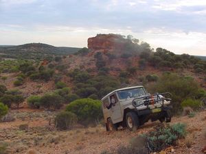
Feral animals include the camel. Pastoral leases lie on the edge of the desert, and in some areas escaped grazing animals such as sheep compete with the local fauna for sparse resources. The Gibson Desert Nature Reserve is popular for visitors with four wheel driver vehicles (which can cause severe habitat damage if used irresponsibly) and is accessible from the famous Gunbarrel Highway.
See also
- List of deserts by area
References
- ↑ Giles, Ernest (1889) Australia Twice Traversed : Hesperian Press, 1995. ISBN 0859052060
- ↑ (http://www.anra.gov.au/topics/rangelands/overview/wa/ibra-gd.html#pest
- ↑ Great Victoria and Gibson Deserts, Western Australia from Climate and Weather Atlas of Australia by Michael Thompson, verified 2006-01-23.
- ↑ Environment Australia. Revision of the Interim Biogeographic Regionalisation for Australia (IBRA) and Development of Version 5.1 - Summary Report. Department of the Environment and Water Resources, Australian Government. http://www.deh.gov.au/parks/nrs/ibra/version5-1/summary-report/index.html. Retrieved 2007-01-31.
- ↑ IBRA Version 6.1 data
- ↑ Gibson desert (AA1303), written by the World Wildlife Fund, from National Geographic magazine.
Further reading
- Thackway, R and I D Cresswell (1995) An interim biogeographic regionalisation for Australia : a framework for setting priorities in the National Reserves System Cooperative Program Version 4.0 Canberra : Australian Nature Conservation Agency, Reserve Systems Unit, 1995. ISBN 0642213712
External links
 Media related to Gibson Desert at Wikimedia Commons
- Gibson Desert 1997; a photo album of the Gibson Desert by Stuart Jackson, Verified 2006-01-23
- Across Australia Motorbike Tour
|
|||||||||||||||||||||||||||||